
ISABEL RUBIO ARROYO | Tungsteno
Since the Russian invasion of Ukraine began, satellites have become an indispensable weapon for armies, intelligence services and humanitarian groups. Hundreds of images captured from the sky document troop movements, damage to infrastructure and even refugee flows. We look at how these devices are being used to assess the situation on the ground and make strategic decisions in this conflict.
The 'spies' in the sky
Even before Russian troops crossed into Ukraine, commercial surveillance satellites were mapping the Kremlin's plans. In February, a few days before Russia invaded the country, Russian President Vladimir Putin said that troops massed on the border were being withdrawn. However, as The Wall Street Journal reports, the satellite images said otherwise and showed, moreover, that Russia had built a bridge from Belarus so that tanks could cross a river into Ukraine. The imaging company Planet Labs PBC, which works with the Pentagon, detected the bridge thanks to its fleet of about 200 satellites that scans the entire country once a day.
While US government satellites are expensive and can take years to build and deploy, commercial satellites are relatively inexpensive and can provide very useful information. While they may not offer images of the highest quality, they have one major advantage: data can be easily shared without the security restrictions that many government satellites are subject to. In addition, there are technologies that can improve the quality of the captured photographs. For example, the Spanish company Tracasa uses deep learning to increase the resolution of images from the European Space Agency's (ESA) Sentinel-2 satellites fourfold, from 10 metres per pixel in each image to 2.5 metres per pixel.

Some technologies can boost the resolution of satellite images. Credit: Tracasa.
Satellites keeping watch in clouds and darkness
Ukraine has benefited from the information gathered by numerous commercial surveillance satellites with different capabilities. In addition to capturing optical images, some can see through clouds and track troop movements at night. This is especially important given that "Ukraine is a tricky place and there is a lot of cloud cover and night operations," says Mike Greenley, CEO of Canadian space technology company MDA. He points out that some satellites can detect where vehicles have moved, even in bad weather, and tanks hidden under trees.
With all this information coming from the sky, Russia has found it difficult to conceal its military actions. Apart from fighting Russian forces, Ukraine also uses satellite imagery to get public opinion on its side by reporting possible war crimes and civilian killings, tracking refugee flows and detecting mass graves in the country. In fact, some humanitarian groups also use the information gathered by satellites to map the chaos and evacuate civilians.

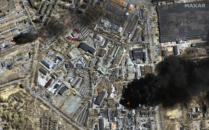
Ukraine uses the imagery to assess the situation on the ground and make strategic decisions to counter the invasion. Credit: Maxar Technologies.
The Russian counteroffensive
Russia is also trying to exploit the potential of satellites in the conflict, but it has a limitation: some analysts suspect it has long been using a small and inadequate fleet of communications and surveillance satellites. These devices, in some cases, rely on obsolete technology or imported parts that are now harder to obtain due to Western sanctions. "In principle, Russia is already practically blind in orbit," Bart Hendrix, a Brussels-based analyst and expert on Soviet and Russian space programs, told US radio corporation Radio Free Europe/Radio Liberty (RFE/RL).
Pavel Podvig, an expert on the Russian military and senior fellow at the UN Institute for Disarmament Research in Geneva, points to another potential problem: data processing. "It's one thing to have satellites; it's another thing to be able to use them. [Russia] needs a system that allows it to quickly transfer information from satellites to the right people who will process it and transfer it to people responsible, for example, for target designation," he says. "The fact that Russia has some satellites still flying does not mean that such a system exists, and if it exists, it is difficult to say how good or bad it is."
The world's major powers are aware of the potential of the images collected by these satellites beyond the invasion of Ukraine. These eyes in the sky can be useful in unravelling the details of all kinds of conflicts. Now, thanks to this kind of imagery, governments can no longer take large-scale military action without everyone knowing about it. As Planet Labs PBC co-founder and CEO Will Marshall notes, “we are moving to a transparent and accountable era through these technologies.”
· — —
Tungsteno is a journalism laboratory to scan the essence of innovation. Devised by Materia Publicaciones Científicas for Sacyr’s blog.